| Description |
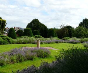
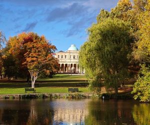
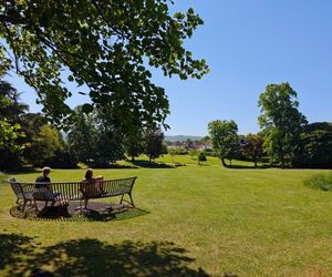
Pittville Park is a large regional park divided in two by Evesham Road. Most people are familiar with the eastern side of the park, which is overlooked by Pittville Pump Room, and home to the main children's play area and the aviaries where you'll find our popular birds and bunnies. However, to the west of Evesham Road lies the much larger western park with its more natural layout and small areas of woodland. Here you will find the larger 'lower lake' where you can fish during the fishing season, and there is a smaller children's play area along with tennis courts, a pitch and putt golf course and a skate park.
|
|---|---|
| Location |
The park borders Tommy Taylor's Lane to the west and Pittville Lawn to the east |
| Site awards | Green Flag award |
| Sport and play |
Multiple play areas across the park - children's, youth, adult, natural play. View the play area map Football field with pavilion in Aggs field. To book email pitch.booking@cheltenham.gov.uk. MUGA (multi use games area), tennis courts, BMX ramps, football pitches, boat hire, pitch and put, pickleball, fishing, cyclecross course, 321 running route, avaries, sensory beds. Cheltenham and County Cycling Club meet for road rides at Pittville pump room. |
| Refreshments |
1. The Kiosk in the children's play area |
| Toilets |
The park's toilet facilities are next to the play area and are normally open during the daytime. There is also a Changing Places facility on site. |
| Seating | Multiple benches and picnic tables |
| Accessible paths | Yes |
| Cycle parking | Yes |
| Car parking | Yes |
| Other information | Defibrillator located at What 3 Words: remote.prefer.reject |
| Friends of group | Friends of Pittville Park |
Parks and open spaces directory
We manage over 100 parks and green spaces in Cheltenham. Our green spaces range from the formal Regency parks such as Montpellier, Sandford and Pittville Lawn, to our wilder green spaces, with a focus on the connection between our communities and wildlife, such as Springfield and Weavers field. Many of our parks have sport and play facilities as well as refreshments. Use our parks directory below to find somewhere new to explore today.
We also have responsibility for a number of nature reserves:
- Leckhampton Hill and Charlton Kings common
- Pilley Bridge
- Griffiths Avenue
| Description |
Imperial Gardens are formal gardens set within a Regency square just off the Promenade, behind the town hall. The Garden Bar is open during spring and summer. During the summer months, the gardens are host to many outdoor events and festivals including the Literature, Jazz, Science and Music Festivals. The gardens are also home to the Holst statue, a bronze statue of Gustav Holst, which is the centrepiece of a fountain surrounded by tall grasses.
|
|---|---|
| Location |
Town centre location, behind the Town Hall. Imperial Square, Cheltenham GL50 1QZ |
| Refreshments | |
| Toilets |
No |
| Seating | Multiple benches |
| Accessible paths | Yes |
| Cycle parking | Yes |
| Car parking | On street |
| Other information | Close to restaurants and cafes in town |
| Friends of group | Friends of Imperial Square Heritage and Conservation |
| Description |
Montpellier Gardens lie close to the town centre and are an important part of Cheltenham's Regency landscape. Many of the buildings surrounding the gardens are listed grade one. You'll find most of the park facilities in the southern section, including toilets, cafe, tennis courts, skate ramps and play area. The larger northern section has open grassy space with a footpath around the outside. In the north-western corner of the park there's a small aboretum where you'll find some interesting and unusual trees.
|
|---|---|
| Location |
Montpellier Walk, GL50 1SD |
| Site awards | Green Flag award |
| Sport and play |
Childrens and youth adult play equipment- View the play area map There are also tennis courts that you can book, skate ramps and climbing and fitness equipment. |
| Refreshments | The Garden Cafe is situated in the park. You'll find many other cafes, bars and restaurants close by |
| Toilets | Yes, with changing places toilet accessed with a RADAR key |
| Seating | Multiple benches and picnic tables |
| Accessible paths | Yes |
| Cycle parking | Yes |
| Car parking | On street parking |
| Other information |
There is a band stand which the Friends organise events for (see Facebook page below), Cheltenham Festivals run events in the gardens. You can also find statues, public art and an arboretum trail. Visit our self guided tree walks page. |
| Friends of group | The Friends of Montpellier Bandstand and Gardens |
| Description |
Situated at the south end of the High Street, Sandford Park is one of Cheltenham's lesser known treasures. It's well used by many as a pleasant route to work, or for quiet lunch breaks in the sun. The ornamental side of the park, where dogs must be kept leads, is closest to town, at the corner of Bath Road and High Street. The main part houses a fountain with seating, landscaped beds, and stunning flower displays in the summer months. A meandering path leads to the restful cascade pools and the River Chelt. The cascades are a popular training ground for ducklings in the springtime and if you are lucky, you may catch a glimpse of a local kingfisher! The Annecy Gardens, named after one of Cheltenham's twin towns, are to the north side of the park, and the Italian Gardens, complete with sunken pool and fountains, lie to the west. The recreational side of the park, south-east of College Road and next to Sandford lido, is popular for picnics and games, and has a large play area, boules court, table tennis and toilets. There's lots to explore here. At the far south end of the park you'll also find the Sanctuary Garden, created in partnership with with LINC (Leukaemia and Intensive Chemotherapy Fund) as a peaceful, beautiful space for LINC patients, families, staff and visitors to the park. There are several pieces of public art in the park. The Visit Cheltenham website has details of public art in Cheltenham

|
|---|---|
| Location |
Either side of College Road. Entrances also on Bath Road and High Street. GL50 1DZ or GL53 7PU |
| Site awards | Green Flag award |
| Sport and play |
Children's and youth adult play area - View our play area map You can also find table tennis, boules court, fitness equipment including accessible units on the same side as the play area. |
| Refreshments | Coming in Summer 2026. Nearby cafe's and pubs in town |
| Toilets | Yes in the summer. Located by the play area |
| Seating | Multiple benches and picnic tables |
| Accessible paths | Yes |
| Car parking | There is a small amount of on road parking found on College road |
| Other information |
There are also gardens run by local community groups including Linc garden and Vision 21 community vegetable garden, Boules - https://cheltenham.u3asite.uk/u3a_groups/boules-petanque/ |
| Friends of group | Friends of Sandford Park |
| Description | Benhall park is a large area of grassy playing fields alongside woodland, with Hatherley Brook running through the middle. There are a number of play areas and sports facilities throughout the park |
|---|---|
| Location |
The park is spread out alongside Whittington and Bibury Roads. GL51 6BD |
| Sport and play |
Multiple play areas across the park - children's, youth, adult, natural play. View the play area map |
| Refreshments |
No |
| Toilets |
No |
| Seating | Multiple benches and sleep benches |
| Accessible paths | Yes - to and from children's play area and gym equipment from Bibury Road |
| Cycle parking | No |
| Car parking | On street parking |
| Friends of group | Benhall residents association. Find out about volunteering with the group |
| Description |
Burrow's Field is around 6.3 hectares of open space in Leckhampton with a brook running alongside. There are sports pitches with a pavilon, a children's play area and pump track. The field is popular with dog walkers and ramblers and has good links to public rights of way, and the wider countryside. Burrow's Field is home to Cheltenham’s largest youth and minis football club, Leckhampton Rovers, and also the Broadlands pre-school play group. There is a strong focus on biodiversity and wildlife. The site benefits from sustainable drainage, native copses, a Gloucestershire variety orchard and native wildflower meadows. |
|---|---|
| Location |
The main entrance to the park is at the end of Moorend Grove, Leckhampton, Cheltenham GL53 0HA, where you'll also find a small car park. |
| Site awards | Fields in Trust |
| Sport and play |
Children's play area. View our play area map Football field with pavilion. Managed by Leckhamton Rovers. Cricket field. To book email pitch.bookings@cheltenham.gov.uk Pump track, fitness equipment |
| Refreshments | |
| Toilets |
Toilets are available at The Dug Out cafe during opening hours |
| Seating | Multiple benches and picnic tables |
| Accessible paths | Yes - circular path |
| Cycle parking | Yes |
| Car parking | Yes |
| Friends of group | Leckhamton Rovers. |
| Description | Cox’s Meadow is a mixture of wetland and wildland. Since the early 2000s it has been part of Cheltenham’s Flood Alleviation Scheme, partly managed by the Environment Agency. Following heavy rain the area turns into a wetland and then once the floodwater has drained back into the River Chelt, it becomes a meadow again. There are footpaths and a cycle path and the meadow is a popular spot in particular for families and dog walkers. |
|---|---|
| Location |
South east Cheltenham. Access from the A40 Old Bath Road, GL53 7FF. |
| Refreshments | |
| Toilets | Toilets are available for customers of the cafe |
| Seating | Multiple benches |
| Accessible paths | Yes - circular path |
| Cycle parking | Yes |
| Car parking | On street |
| Other information |
Cycle route An oak copse has been planted here in partnership the Gloucestershire Live 'Our'boretum project. Local people planted an acorn and then transplanted the saplings in the park. |
| Friends of group | Friends of Cox's meadow |
| Description |
Hatherley Park is a charming ornamental garden of around 3 hectares with playing fields, play areas and a lake. There is also a wildlife pond and a circular path which loops around the edge of the park. In the park you will find a number of interesting mature specimen trees and shrubs. Some of these mature trees line the main path and provide a stunning array of autumn colour. Species include gingko biloba, hornbeam, willow and a number of species of birch.
|
|---|---|
| Location |
Access the park from Hatherley Court Road and Bournside Road, GL51 3AL. |
| Site awards | Green Flag award |
| Sport and play |
Children's, youth and adult play areas. View the play area map Football field. To book email pitch.bookings@cheltenham.gov.uk Boules. Visit the Cheltenham u3a website for details of meetings |
| Refreshments | |
| Toilets |
No |
| Seating | Multiple benches and picnic tables |
| Accessible paths | Yes |
| Cycle parking | Yes |
| Car parking | On street parking |
| Other information |
Defibrillator located at pavilion. Public art, notice boards and interpretation boards. |
| Friends of group | Friends of Hatherley Park |
| Park management plan |
| Description |
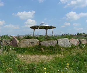
A large green space which sits between GCHQ and the Gloucestershire College campus, Hesters Way park was opened in 1957. The park has a play area and a number of mature trees. These include the cypress oak, the Indian Bean tree, a Causasian wing-nut, groups of Persian Ironwoods and several varieties of conifers. In the park you'll find the Listening Stones - nine standing stones carved from glacial granite, commissioned by GCHQ. Part of the West Cheltenham Public Art Trail. |
|---|---|
| Location |
Access from Princess Elizabeth Way and Kempton Grove. GL51 0GH or GL51 0JU. |
| Sport and play |
Childrens play area. View the play area map |
| Toilets |
No |
| Seating | Multiple benches |
| Accessible paths | Yes |
| Cycle parking | No |
| Car parking | On street parking |
| Other information | Locally known as Fishy Park as there used to be multiple fish ponds |
| Description |
The Honeybourne Line is a former railway line which is now a walking and cycling route and nature reserve. It runs from Cheltenham railway station and Queen's Road to Tommy Taylors Lane, Pittville Park and Wymans Brook as well as branching off towards the town centre following the River Chelt. You'll find play equipment to the north in Winston Churchill Memorial Garden and the south towards Queen's Road, along with outdoor keep-fit equipment. There's a 2km running route from Queen's Road bridge to the southern edge of the Prince of Wales Stadium. This is marked by a start and finish map sign. All the paths and access points for pedestrians and cyclists along this leafy line are available to view on our Honeybourne Line Google map. The Honeybourne Line is an important wildlife corridor and small mammals and foxes are frequent visitors. Many species of butterfly including a Small Blue colony have been seen along the line and it has a selection of common native plants usually associated with disused railway lines. |
|---|---|
| Location | The line runs from Queen's Road directly opposite the entrance to Cheltenham Spa railway station (GL50 2NH) through to Prince of Wales Stadium in Pittville (GL50 4BY) |
| What 3 Words |
Queen's Road entrance: mime.head.arch |
| Sport and play |
Children's and youth play area. View the play area map Fitness equipment rail and 2k running route |
| Toilets |
No |
| Seating | Multiple benches |
| Accessible paths | Yes and cycle route |
| Cycle parking | No |
| Car parking | No |
| Other information | Pollinator corridor. Hosts Cheltenham paint festival each year with free walls for graffiti |
| Friends of group | Friends of Winston Churchill Memorial Gardens |
| Description | Large playing field in West Cheltenham with multiple football and rugby pitches, 2 pavilions, public art and seating area |
|---|---|
| Location |
Rowanfield. Access from Brooklyn Road, GL51 8DT and Buckingham Avenue, GL51 8DB. |
| Site awards | Fields in Trust |
| Sport and play |
Children's, youth, adult & natural play areas. View the play area map Football and rugby pitches. To book football email pitch.bookings@cheltenham.gov.uk. Some pitches are managed by Saracens FC and Saracens RFU club. MUGA (multi-use games area) and basketball hoop. |
| Toilets |
No |
| Seating | Some benches and sleeper benches |
| Cycle parking | Yes |
| Car parking | Yes |
| Other information | Parkrun weekly. Community orchard. Notice board. Fields in Trust award |
| Friends of group | Friends of KGV |
| Description |
Naunton Park is made up of a large recreational area and a formal rose garden. The recreational side is a large green space with a path around the outside, cafe and play ground facilities. The rose garden is formally laid out with paths and seating. The garden has a historical connection to the arms houses. |
|---|---|
| Location |
Naunton Lane, GL53 7BG. Parking available in car park on Asquith Road, GL53 7EJ. |
| Site awards | Green Flag award |
| Sport and play |
Childrens and youth adult play areas. View the play area map Football and cricket field with pavilion. To book email pitch.bookings@cheltenham.gov.uk There is also a MUGA (multi-use games area) |
| Refreshments | Naunton Park Pavilion |
| Toilets | When the cafe is open there is one for customers |
| Seating | Multiple benches and picnic tables |
| Accessible paths | Yes |
| Cycle parking | Yes |
| Car parking |
Yes on Asquith Road. what3words ///paint.debit.even |
| Other information |
There is a pavillion used by football and cafe. In 2025 a project was completed with Gloucestershire Wildlife Trust and Cheltenham Borough Council creating swales which are a natural flood management scheme. Visit Gloucestershire Wildlife Trust for more information. |
| Friends of group | Friends of Naunton Park |
| Description | QEII sits on an old landfill site converted into a green open space. It is surrounded by mature trees with panoramic views from the top of the slope. Wildflower areas and young copse trees have been planted in recent years to create dynamic views and biodiverse habitat. |
|---|---|
| Location |
Access from Haywards Road/King Alfred's Way |
| Site awards | Fields in Trust |
| Sport and play |
Childrens and youth adult. Natural play areas - View our play area map There is also a basketball court. |
| Seating | Some sleeper benches and a picnic table |
| Accessible paths | Small amounts of accessible pathways at each entrance |
| Car parking | Yes |
| Other information | Queens Green Canopy copse planted here in 2022 in commemoration of the Platinum Jubilee. Fields in Trust. Traditional orchard planted in 2024 by the Friends group in partnership with Gloucestershire Orchard Trust |
| Friends of group | Friends of QEII |
| Description |
A large park next to Springbank Community Resource Centre with sports pitches and accessible and natural play equipment. Springfields has been landscaped with ditches, ponds and wild planting for wildlife.
|
|---|---|
| Location |
The the west of Cheltenham, between Springbank Way, Welsh Road and Hesters Way Lane. |
| Site awards | Green Flag award |
| Sport and play |
Childrens and youth adult. Natural play areas - View our play area map There is a football field. To book email pitch.bookings@cheltenham.gov.uk. There are natural play areas across the park. You can also find a zipline, half pipe, BMX track, MUGA (multi-use games area) and youth shelter. |
| Refreshments | Springbank Community Cafe |
| Toilets | There are toilets in the community centre |
| Seating | Yes, there are multiple benches and picnic tables |
| Accessible paths | Yes |
| Cycle parking | Yes |
| Car parking | Yes |
| Description |
St Peters Park, Chelt Walk is a green corridor along the River Chelt, between Princess Elizabeth Way and Saracens football club. |
|---|---|
| Location |
Main access from Princess Elizabeth Way, GL51 7NY. |
| Sport and play | Childrens and youth adult play areas - View our play area map |
| Seating | Multiple benches |
| Description | A large playing field in Swindon Village, with mature oaks and a Queen's Green Canopy copse planted in 2022 in commemoration of the Platinum Jubilee |
|---|---|
| Location |
Wymans Lane, Swindon Village, GL51 9QH. |
| Sport and play |
Children's play area - View our play area map There is also a football and cricket field with pavilion. To book email pitch.bookings@cheltenham.gov.uk. |
| Seating | Some benches |
| Accessible paths | Partially |
| Car parking | Yes |
| Other information | Pavilions. Local toddler group. Queen's Green Canopy copse |
| Description | Fields in Trust site with native wild flower meadow, old orchard and newly planted community orchard. Panoramic views from top of small hill |
|---|---|
| Location |
Access from Caernarvon Road or Greatfield Land (off Salisbury Avenue), GL51 3QZ. |
| Site awards | Fields in Trust |
| Other information | Events throughout year. Flood alleviation scheme |
| Friends of group |
| Description |
Winston Churchill Memorial Garden is a small urban park discreetly tucked behind the Lower High Street shops. The gardens have a number of historical features such as the formal rose garden, pergola, clipped yew avenue and St Mary's Mission building. It is still possible to see some of the headstones along the northern perimeter wall. The eastern boundary has been planted with native dog rose and wild flowers and there's also a linear orchard running along Market Street to the south.
|
|---|---|
| Location |
GL50 3JA. Between Lower High Street and Market Street. Also accessible from the Honeybourne Line. |
| Site awards | Green Flag award |
| Sport and play | Childrens play area - View our play area map |
| Refreshments | No but you'll find plenty nearby on the lower high street |
| Toilets | No |
| Seating | Multiple benches and picnic tables |
| Accessible paths | Yes |
| Cycle parking | Yes |
| Car parking | Yes |
| Other information |
The large grey building watching over the park is called the Mission building. It is grade 2 listed. Near the centre of the rose garden are bricks in the path with words, phrases and simple line drawings gathered from local children and adults to symbolise how they feel about the gardens. The images are pressed into blue engineering bricks, once used on the railway line that runs parallel to the gardens. |
| Friends of group | Friends of Winston Churchill Memorial Gardens |